


With the changing political landscape in Bangladesh, China is again at its old game of wolf warrior diplomacy in Dhaka.
Taking advantage of the anti-India rhetoric being promoted in Bangladesh under the Interim Government led by Mohammed Yunus, Beijing demands that Dhaka change the map of Asia and texts in Bangladeshi textbooks and the Department of Survey website.
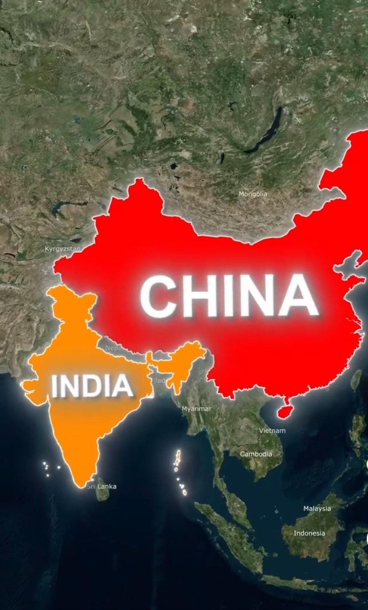
These correctly depict now Arunachal Pradesh and Aksai Chin as parts of India, but Beijing wants Dhaka to show them as parts of China. Beijing also wants Arunachal Pradesh to be renamed as ‘Zangnan’ in Bangladeshi maps.
Borrowing from the doctrine of Minister of Propaganda of German Third Reich Joseph Goebbels that a falsehood repeated ad infinitum will convert it into truth, Beijing routinely keeps claiming Arunachal Pradesh and Aksai Chin are Chinese territories. Threatening Bangladesh to change its maps is, however, more than propaganda. It is coercion.
A report in the Bangladeshi newspaper Prothom Alo quoting diplomatic sources says that in a letter to Bangladesh in the last week of November, China raised objections regarding two Bangladeshi textbooks and a map of Asia displayed on the website of the Department of Survey, claiming that Arunachal Pradesh and Aksai Chin had been incorrectly depicted as part of India and maintaining that these two territories had historically belonged to China. Beijing also wanted Dhaka to correct the maps and the information presented in the textbooks and the survey department website.
Now nothing can be further from the truth than the claim of China on Arunachal Pradesh and Aksai Chin. It is a well-known historical fact documented in diaries and travelogues of British civil and military officers on posting in India that the eastern part of Arunachal Pradesh inhabited by warlike tribes had little contact with Tibet and had gradually been brought under the administrative control of British India. The Tibetan administration extended to the Tawang tract. China had never, however, set its footprint in any part of Arunachal Pradesh; whether the tribal areas or Buddhist Tawang. By the Tripartite Simla Agreement of 1914, signed between the Great British, China and the administration of an independent Tibet under the 13th Dalai Lama, the boundary was established in form of the McMohan Line, which separated British India from China and Tibet. The McMohan line clearly included the Tawang region of Arunachal Pradesh as part of British India.

It is also a historical fact that Aksai Chin belonged to Ladakh since the days of the Namgyal dynasty and the Dogra kingdom. Being a remote area, surveillance was not strong, though India used to send police and military patrols occasionally to Aksai Chin since the days of Ladakh joining the Indian Union. Taking advantage of this and the trust India had placed in China under the Panchsheel Agreement, the Chinese authorities built the Western Tibet Highway through Aksai Chin.
To the chagrin of Beijing, a textbook for students of classes IX and X titled ‘Bangladesh and Global Studies’ which includes a list of Bangladeshi export destinations has designated Taiwan and Hong Kong as countries. Now Beijing is mounting pressure on Dhaka that these areas be shown as Chinese territories.
Beijing in its diplomatic note has insisted on calling Arunachal Pradesh ‘Zangnan,’ a Chinese name the mandarins of the Chinese Communist Party have invented. This time around, however, the CCP mandarins have not found ready accommodation by Dhaka as the National Curriculum and Textbook Board of Dhaka has informed that the process of printing the new textbooks has already been completed; leaving no opportunity for correction at this stage. Besides, what China has claimed to be an “error” has been printed in the same way for a long time and amendments could not be made abruptly. The issue would be addressed at a later stage in a coordinated manner.
Beijing has lately been inventing all sorts of Chinese names also for places in Tibet which has been under illegal occupation of China since 1959. These are attempts to wipe off the history of the places which China wants to occupy illegally and to create a false Chinese identity for them. The most blatant among these is the conspiracy to replace ‘Tibet’ with ‘Xizang’ in the official records of China. To counter the Chinese conspiracy, Sikyong Penpa Tsering, the President of the Tibetan Government-in-Exile, has announced the composition of a book and map with the original names of Tibetan counties.
ANI has quoted Penpa Tsering, saying: “The Chinese cartographic aggression is not only against Tibet. They are doing it in the East China Sea, in the South China Sea, with India in Arunachal Pradesh and Ladakh. This is the overall policy of the Chinese government in expanding their territorial claims in the regions.
This is not the first time, however, that China has threatened Bangladesh with its wolf warrior diplomacy. In May 2021, a Chinese diplomat posted in Dhaka threatened Bangladesh not to join the QUAD, of which Australia, Japan, India and the USA are members. “We do not want any form of participation of Bangladesh in this alliance,” Chinese Ambassador in Dhaka Li Jiming had said. The Chinese threat had not gone down well with Bangladesh on that occasion. Bangladesh Foreign Minister A. K. Abdul Momen had described the remarks by the Chinese Ambassador as “very unfortunate” and “aggressive.” He had said: “We are an independent and sovereign state. We decide our foreign policy.”
In yet another instance of coercive diplomacy practised by China in Bangladesh, in 2016, at the Dhaka Art Summit, one of the biggest art shows in Bangladesh, Tibetan artists had to cover up an exhibit as it had offended the Chinese embassy.
It was a photographic piece featuring letters from five Tibetans who had committed self-immolation in protest against Chinese rule.
The Chinese Ambassador in Bangladesh had demanded that the art pieces be removed, threatening serious consequences.
China’s actions regarding maps and territorial claims are interference in other nations’ sovereignty. While it advocates for non-interference in principle, its actions in various regions suggest otherwise.
Because it considers maps as symbolic of sovereignty and national integrity, China responds strongly when other countries issue maps that conflict with its territorial claims, using it as an excuse to legitimize intervention, ignoring the other nation’s sovereignty.
Bangladesh must address these aggressive cartographic practices and ensure that its integrity and sovereignty are respected.


